
💡 Severe Thunderstorm Watch: A Strategic Safety Analysis
An authoritative guide on severe thunderstorm watches, atmospheric science, economic impacts, and strategic preparedness protocols for professionals and households.
Executive Summary
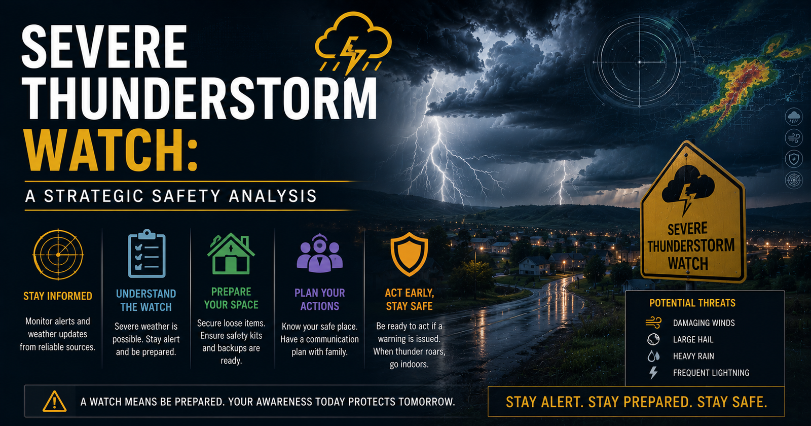
A severe thunderstorm watch is a critical meteorological designation issued when atmospheric conditions demonstrate a high probability for the development of organized severe weather. This analysis examines the technical criteria used by the Storm Prediction Center, the economic implications of convective storms, and the strategic protocols required for infrastructure resilience. Key data indicates that severe convective storms contributed to over 50 billion dollars in insured losses globally in 2023, highlighting the necessity of understanding these alerts. This guide provides a comprehensive framework for interpreting weather data and implementing risk mitigation strategies.
Introduction: The Mechanics of Atmospheric Instability
Meteorological phenomena are not merely environmental events; they are complex systemic disruptions that require precise forecasting and strategic response. A severe thunderstorm watch serves as the primary signaling mechanism for potential hazards including damaging winds, large hail, and frequent lightning. Unlike a warning, which indicates an immediate threat, a watch signifies a window of vulnerability usually lasting between four to eight hours. Understanding the transition from atmospheric instability to a formal alert is essential for maintaining operational continuity in sectors ranging from logistics to public safety.
The issuance of a watch is predicated on the presence of four key ingredients: moisture, instability, lift, and wind shear. When these factors align, the Storm Prediction Center (SPC) in Norman, Oklahoma, coordinates with local National Weather Service offices to alert the public. This collaborative framework ensures that regional variations, such as those discussed in our Delhi UP Bihar Weather Strategic Climate Analysis, are accounted for within a broader global meteorological context.
The Deep Dive: Technical Criteria and Economic Impact
The National Weather Service defines a severe thunderstorm as one that produces wind gusts of at least 58 miles per hour (50 knots) or hail at least one inch in diameter. While lightning is a core component of these storms, it is not a defining criterion for the 'severe' classification because all thunderstorms contain lightning. The strategic importance of a watch lies in its ability to provide lead time, often several hours before convective initiation occurs.
The Role of Convective Available Potential Energy (CAPE)
Forecasters monitor CAPE, a measure of the amount of fuel available for a developing storm. High CAPE values, often exceeding 2,000 Joules per kilogram, suggest the potential for explosive updrafts. When combined with significant vertical wind shear, these updrafts can become tilted and rotating, leading to organized storm modes such as supercells or quasi-linear convective systems (QLCS). These systems pose a direct threat to the infrastructure managed by industrial Giants who oversee the power grids and transportation networks of major metropolitan areas.
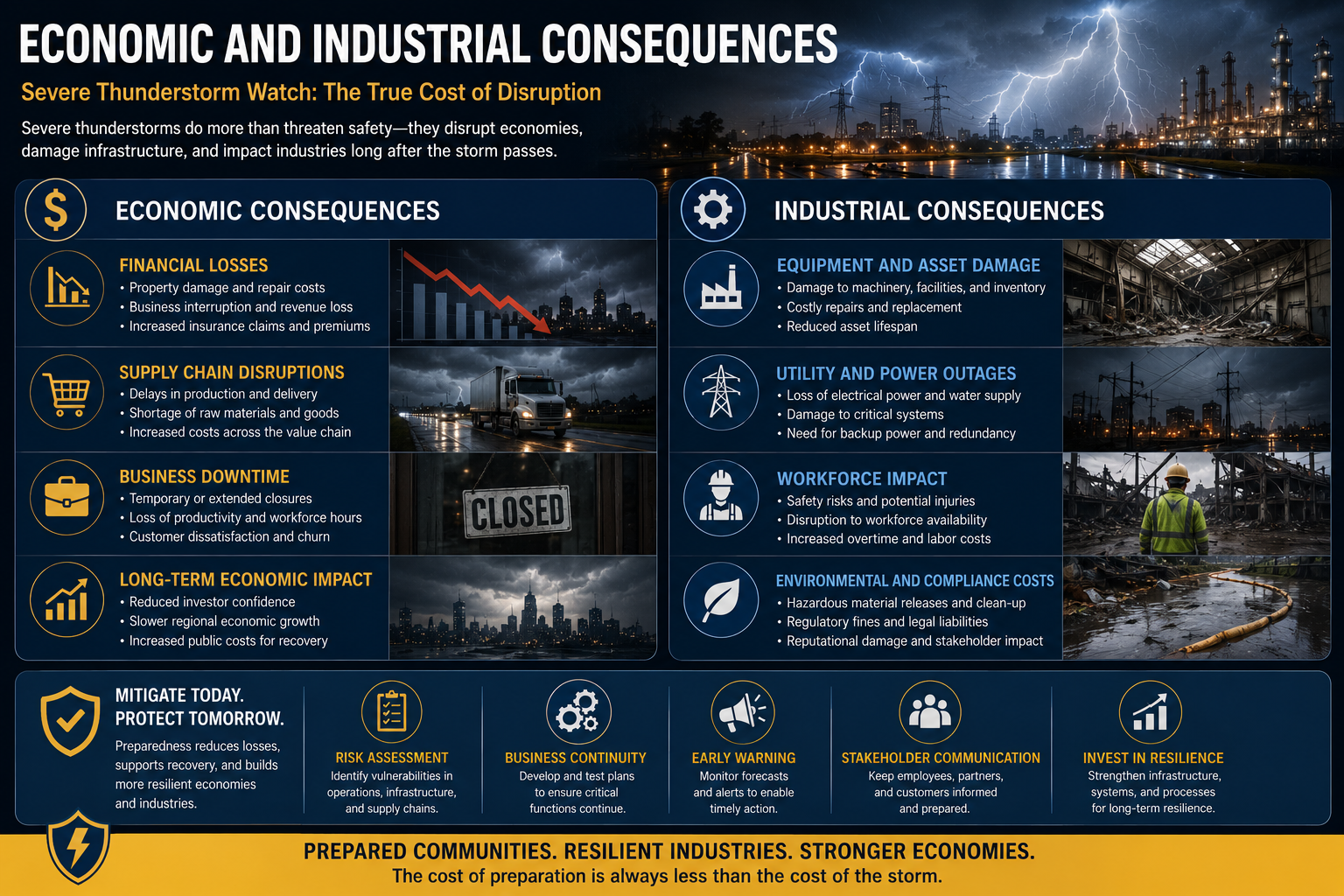
Economic and Industrial Consequences
The financial ramifications of severe weather extend beyond immediate property damage. Supply chain disruptions are a primary concern for global markets. For instance, severe storms in the Gulf Coast or the Midwest can impact refinery operations and transport routes, which in turn influences international Oil Prices and energy stability. In 2023, the United States experienced a record 28 separate billion-dollar weather and climate disasters, many of which began as severe thunderstorm watches that escalated into high-impact events.
Institutional Framework and Forecasting Technology
The evolution of forecasting relies heavily on the GOES-R series satellites and Dual-Polarization Radar. These tools allow meteorologists to distinguish between different types of precipitation and non-meteorological objects, such as debris. The High-Resolution Rapid Refresh (HRRR) model provides hourly updates, allowing for a dynamic assessment of storm evolution. This technological edge is what allows the SPC to maintain a high probability of detection while minimizing false alarm ratios, a balance critical for maintaining public trust in emergency management systems.
What This Means For You: Strategic Preparedness
Navigating a severe thunderstorm watch requires a proactive rather than reactive stance. For the general public and business operators, the following protocols are recommended:
- Monitor Official Channels: Utilize NOAA Weather Radio and verified emergency alert apps. Avoid relying solely on social media, which can suffer from latency and misinformation.
- Secure External Assets: In industrial settings, this involves securing loose equipment and reinforcing structures. In residential settings, it means moving vehicles to garages and securing outdoor furniture.
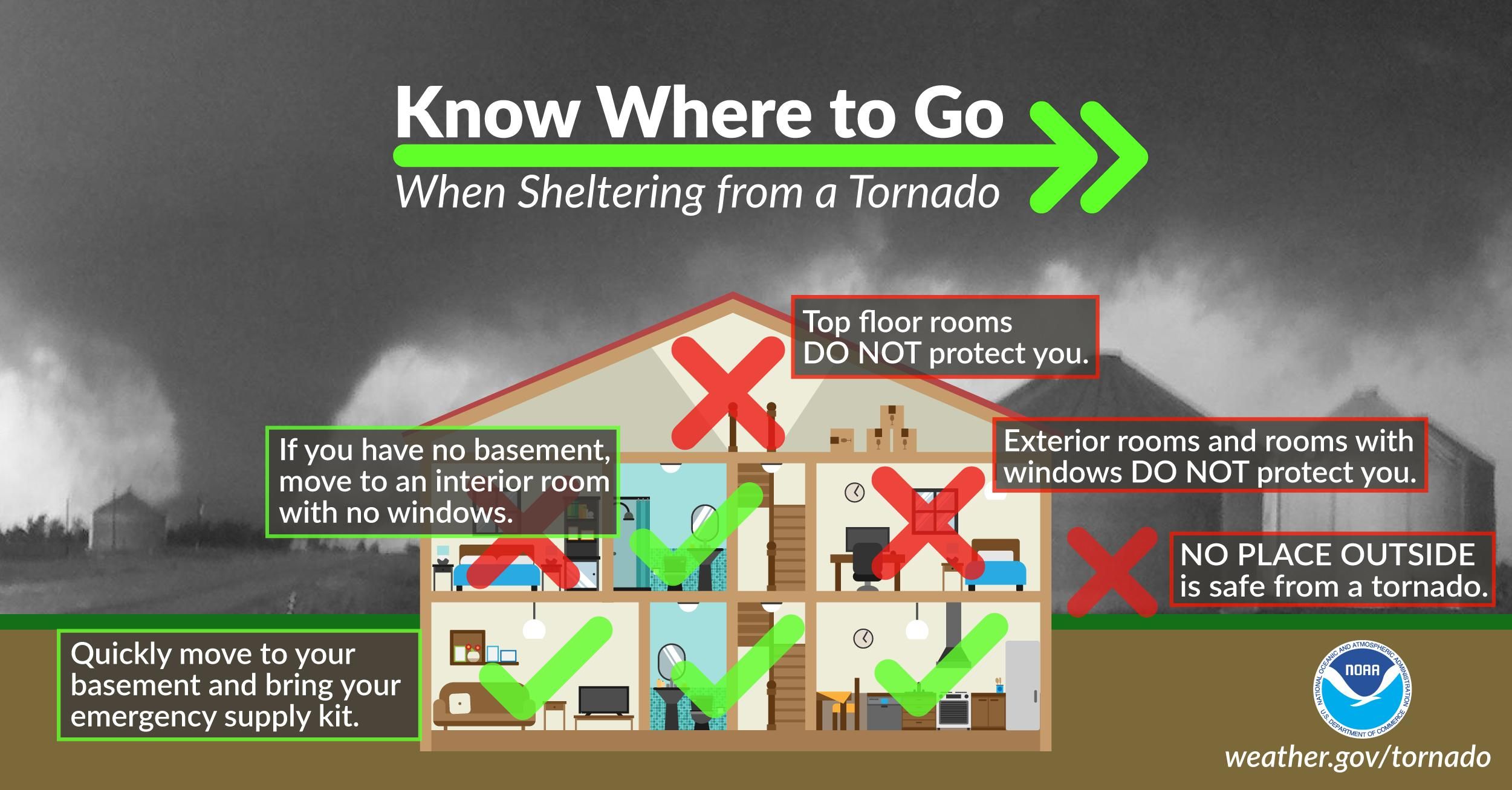
- Review Emergency Communication Plans: Ensure that all team members or family members know where the designated safe room is located. A safe room should be an interior space on the lowest floor, away from windows.
- Charge Essential Devices: Power outages are the most common outcome of severe thunderstorms. Maintaining charged communication devices is vital for receiving subsequent warnings.
Expert Verdict and Future Outlook
The future of severe weather monitoring is shifting toward Warn-on-Forecast (WoF) systems. This paradigm moves away from purely observation-based warnings toward ensemble-based probabilistic forecasting. By using high-density data, meteorologists hope to increase lead times from minutes to hours, potentially saving billions in preventable damage. As climate volatility increases, the frequency of severe convective storms is expected to rise, particularly in regions previously considered low-risk. This necessitates a global shift in building codes and infrastructure design to withstand higher wind loads and larger hail impact energies.

Frequently Asked Questions
What is the difference between a watch and a warning?
A watch means that severe weather is possible and you should remain alert. A warning means that severe weather is occurring or imminent in the specified area, and immediate action is required to protect life and property.
How long does a severe thunderstorm watch typically last?
Most watches are issued for a duration of four to eight hours. However, they can be canceled early if conditions stabilize, or replaced by a warning if a specific storm develops severe characteristics.
Can a severe thunderstorm watch turn into a tornado watch?
Yes. If atmospheric conditions change and the threat of rotation increases, the Storm Prediction Center may upgrade a severe thunderstorm watch to a tornado watch. In some cases, a 'Particularly Dangerous Situation' (PDS) tag may be added to highlight enhanced risk.
Is it safe to drive during a severe thunderstorm watch?
While driving is possible during a watch, it is advisable to plan routes that allow for quick access to sturdy shelter. High-profile vehicles are especially vulnerable to the sudden wind gusts that can precede the rain core of a storm.
Does a watch cover a specific city or a larger region?
Watches are typically regional, covering multiple counties or even entire states. They are designed to encompass the entire area where the environment is conducive to storm development, whereas warnings are much more localized and storm-specific.
Conclusion
A severe thunderstorm watch is a sophisticated risk-assessment tool that demands professional attention. By understanding the underlying atmospheric science and the strategic necessity of early preparation, individuals and organizations can significantly reduce their vulnerability to convective hazards. As forecasting technology continues to advance, the ability to translate these alerts into actionable safety protocols remains the most effective defense against the unpredictable nature of severe weather. The strategic takeaway is clear: awareness during the watch phase is the foundation of resilience during the warning phase.


Comments 0
Leave a Reply
Your email address will not be published. Required fields are marked *
Be the first to share your thoughts!