As atmospheric conditions shift across the United States, the National Weather Service (NWS) has issued a series of Fire Weather Watches and warnings, signaling a period of heightened vigilance for residents in the Central and Western regions. A Fire Weather Watch is a critical alert issued when the convergence of low humidity, exceptionally dry fuels, and high winds creates an environment where wildfires can ignite easily and spread with uncontrollable speed. These watches serve as a precursor to Red Flag Warnings, providing communities with the necessary lead time to prepare for potentially life-threatening conditions.
The current meteorological landscape is defined by a volatile mix of record-breaking temperatures and powerful wind systems. Across the Great Plains and the Rocky Mountain front, the lack of recent precipitation has left vegetation—often referred to as "fuels" by meteorologists—dangerously dry. When these conditions are met with sustained high winds, the risk to public safety and property escalates exponentially. Understanding the nuances of these alerts is the first step in mitigating the impact of nature’s most unpredictable elements.
Current Fire Danger in Colorado and the Denver Metro Area
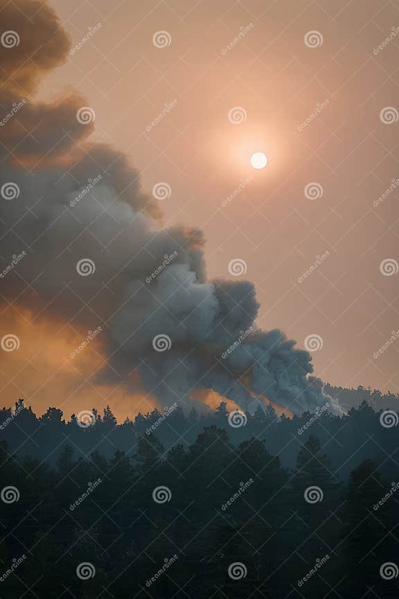
Colorado has recently found itself at the epicenter of this weather activity. Powerful winds have swept through the state, bringing a renewed sense of fire danger to the Denver metro area and the Eastern Plains. According to reports from KDVR, the impact of these winds has been both immediate and damaging. High wind gusts on Thursday resulted in widespread power outages, structural damage, and the closure of several major roadways across the state. The sheer force of the wind has not only hampered travel but has also created a scenario where any spark could rapidly evolve into a fast-moving blaze.
While meteorologists note that wind speeds have fluctuated slightly, the underlying fire danger remains a primary concern. CBS News reports that the combination of these winds and dry surface conditions continues to threaten the Denver metro region. Even as gusts occasionally dip, the cumulative effect of the wind on soil and fuel moisture keeps the threat level elevated. The Eastern Plains, characterized by vast stretches of dry grassland, are particularly vulnerable to wind-driven ignitions that can outpace emergency response efforts.

Weather Alert Days: Nebraska and the Central Plains
The threat is not contained within Colorado’s borders. In Nebraska, specifically around the Lincoln area, local news outlets like KOLN have declared a "Weather Alert Day" for the upcoming Sunday. This designation highlights a period of expected atmospheric volatility where high winds and fire threats are projected to persist through the night and into the weekend. The Central Plains are currently navigating a transition period where breezy to windy conditions are the norm, complicating fire suppression efforts.
Communities in Nebraska are being urged to remain vigilant as these breezy conditions escalate. Local emergency management teams are closely monitoring the situation, as the predicted wind patterns for Sunday could exacerbate any existing fire starts. The "Weather Alert Day" status serves as a formal notification to the public that weather conditions will likely impact daily routines and necessitate increased caution regarding any activity that could produce heat or sparks.
Record Highs and Active Fire Weather Warnings
In addition to the wind, temperature records are being challenged across the Southwest. Reporting from KOAT indicates that record-high temperatures this afternoon are further drying out the landscape, significantly reducing fuel moisture levels. This heat acts as a catalyst, making grass, brush, and timber more susceptible to ignition. In many of these areas, the situation has already transitioned from a Fire Weather Watch to active Fire Weather Warnings, commonly known as Red Flag Warnings.
The distinction between a watch and a warning is critical: a watch means conditions are possible, while a warning means critical fire weather conditions are either occurring or will occur shortly. The Southwest is currently grappling with this reality as the combination of record heat and breezy conditions creates a "perfect storm" for wildfire activity. Meteorologists are keeping a close eye on these regions, as the lack of cooling overnight prevents humidity levels from recovering, further stressing the environment.

The Science of Fire Weather: Wind, Heat, and Humidity
The mechanics of fire weather are rooted in the relationship between the atmosphere and the earth's surface. High winds are perhaps the most dangerous variable; they provide a constant supply of oxygen to a fire and can carry embers miles ahead of the main fire front, creating "spot fires" that make containment nearly impossible. Furthermore, wind accelerates the evaporation of moisture from plants, turning living vegetation into ready-to-burn fuel.
Humidity also plays a silent but deadly role. When relative humidity drops into the single digits or low teens, the air becomes a sponge, pulling every bit of moisture out of the ground. This is often when "dry lightning" becomes a concern—thunderstorms that produce lightning but no rain. However, during a Fire Weather Watch, human-caused sparks remain the leading cause of ignitions. From dragging trailer chains to improper cigarette disposal, the margin for error is zero when the Red Flag criteria are met.
Safety Precautions and Emergency Preparedness
When a Fire Weather Watch is issued, residents must take immediate steps to protect their property and lives. Public safety officials recommend a total ban on outdoor burning, including fire pits and charcoal grills. Additionally, residents should avoid using equipment that creates sparks, such as lawnmowers or grinders, during the heat of the day. Ensuring that trailer chains are not dragging on the pavement is another simple but vital precaution that can prevent roadside fires.
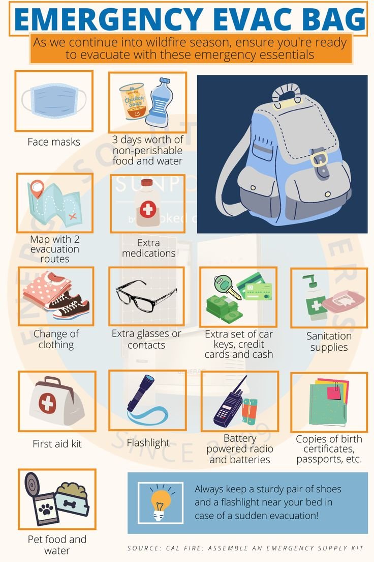
For those living in high-risk zones in Colorado, Nebraska, and the Southwest, having an evacuation plan is essential. This includes preparing a "Go Bag" with essential documents, medications, and supplies. In a wind-driven fire event, evacuation orders can come with very little notice. Knowing your exit routes and having a communication plan with family members can make the difference in a crisis. Community vigilance—reporting smoke immediately and staying tuned to local weather updates—is the cornerstone of wildfire defense.
Conclusion: Staying Informed During Volatile Weather
As the 2026 weather patterns continue to bring volatility to the US Plains and Mountain regions, staying informed is more important than ever. Real-time updates from trusted local news outlets like CBS News, KDVR, and KOLN provide the specific, localized information necessary to navigate these high-wind events. The current Fire Weather Watch is a reminder of the power of the elements and the necessity of community preparedness.
While the winds may occasionally slow, the underlying conditions of dry fuels and low humidity mean the danger is far from over. By respecting the alerts issued by the National Weather Service and taking proactive safety measures, residents can help reduce the risk of catastrophic wildfires and ensure the safety of their communities during these challenging weather cycles.